P.O Box 1424, Kamwenge | Tel: +256787349429 | E-mail: [email protected]

Location & Size
Location & Size
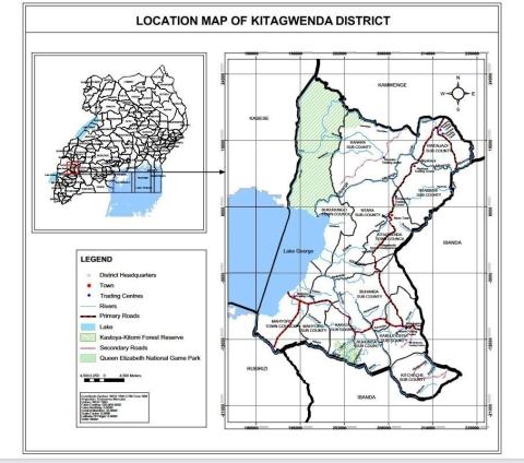
Kitagwenda district is located in Western Uganda. It was originally part of the mother Kamwenge district covering. The district covers approximately a total land area of 2,662.5 km2 of which 2,256.5 km2 is land and 406 km2 is water. Land is the principle natural resource the district is endowed with and forms the basis for development, through agricultural production. Land resource provides opportunities for agricultural expansion for both food security and generation of house hold income, with approximately 80% of the district’s population directly dependent on agriculture for survival and Physically the district lies approximately on latitudes 1o 33I and 2o 23I North of the equator, 30o 01I and 34o 18I degrees East of the Prime Meridian and is over 2500 feet above with dotted Lake George rocks throughout most of it. Kitagwenda District is bordered by Kabarole District to the northwest and north, Kamwenge District to the northeast, Ibanda District to the east and southeast, Rubirizi District to the southwest and Kasese District to the west
Map of Kitagwenda District
KEY GEOGRAPHICAL INFORMATION
The topography is an undulating landscape that includes plateaus, hills and part of the Western Rift Valley of East Africa that is covered by Queen Elizabeth National Park. There are several hills and streams in the district that are fertile and favours banana and coffee growing especially in the areas of Kigoto, Kagazi, Nganiko, Kikondo, Nsinda and other escarpments sloping to Lake George and valleys and plains that make a beautiful scenery across the district. The district lies at an altitude ranging from 1,300- 3,800 meters above sea level. It is crossed by the equator through Lake George and Kitagwenda Town Council. The climatic description of Kitagwenda is based on Western Region climatic zone. It receives bimodal rainfall (March-May and August-November) estimated at 700-1,400mm annually with temperatures ranging from 20-25 degrees celcious. August- November is the main production season for agricultural activities.
NATURAL ENDOWMENTS
Kitagwenda District is endowed with various natural resources in terms of flora and fauna. The relief and topography offer a unique scenery of plateaus and valleys. The magnificent scenery of Mount Rwenzori (Mountains of the Moon) and part of the Western Rift Valley where Queen Elizabeth National Park extends, and the existence of forest reserves of Kasyoha, Kakasi and Kitomi are assets for the district and potentials for tourism. Lake George (Ramseur site and Bird Sanctuary) and River Mpanga Gorge and Mpanga Hydro Power Plant are important sites for fishing, fish breeding and hydro power generation which are development potentials for the district and the country. Protection of these site against encroachment, water diversion and contamination by any project will have impact on electricity generation and fish breeding. There is need to create a tourism circuit to harness these resources in the Tourism program. Some projects along or within these areas must be thoroughly studied to ensure sustainable environmental management and development. 12 Mineral deposits are found in Kitaka where gold has been mined by various companies but have not yielded social economic development to the community apart from negligible royalties that go the district. Generally, there is high rate of natural resource utilization than replacement in terms of tree planting, swamp restoration and protection.
TOURISM DEVELOPMENT
Tourism in Kitagwenda is not developed due to poor infrastructure like hotels, roads and publicity. There are physical features that will attract tourists if well planned and publicised to attract tourism investment in the district as it is driven by the private sector. Local tourism is one way for improving the programme but no initiatives have done.
Climate
The climate of the district is modified by the large swamp area sorrounding it. The rainy season is March to November, with a marked minimum in June, and marked peaks in April to May and August to October. December and January are the driest months. Of recent rainfall has been unreliable and unpredictable hence affecting the activities of people e.g agriculture, livestock rearing etc.
Rainfall
Rainfall normally ranges from 1000mm to 1500mm coming in two seasons; March–July and September – November. There is normally a short dry spell between the two rain seasons during mid June – mid July. The long dry season sets in during late November through to early March. The distribution is such that areas bordering Northeast experience earlier dry seasons. This is also a common occurrence at the lakeshore areas, which sometimes experience very sharp spells of drought.
Temperature, Humidity, Wind and Evapo-Transpiration
The district generally records a mean annual maximum temperature of around 31.3o C and a mean minimum of around 18oC. Its extreme highest temperatures are in the month of February when it records approximately 35oC. The highest ever recorded was in February 1949 where temperatures reached 40oC.
Relative humidity ranges from 66% to 83% at 0600GMT in the morning. However, it reduces much in the afternoon (35%-57% at 1200GMT) thereby reducing chances of rainfall. The southwards passage of the inter-tropical convergence zone in October would appear to bring no more rain than is sufficient to produce a gradual falling off from the July peak. There are relatively high rates of evaporation in Kitagwenda District as it lies near the equator. Evaporations are particularly high in the dry seasons.
Geology and Soils
Most of the areas in Kitagwendai district are underlain by rocks of the basement complex Precambrian age that include granites, mignalites, gneiss, schists and quartzites especially in areas of Kinyamugara and some parts of Kabujogera.
Vegetation
The vegetation of Kitagwenda is typically savannah grassland, shrubs and some pockets of forests with black loam soils, sandy and clay as the main soil types on which all flora and fauna survive. Thick tropical forest cover remains intact in Kakasi Forest Reserve, (Uganda Wildlife Authority), Kitomi-Kasyoha Forest Reserve (NFA), otherwise most of the natural forests which were not under government ownership were depleted and are farmlands. Natural vegetation remains intact in Queen Elizabeth National Park. It’s important to note that River Mpanga and Lake George are synonymous with ecological balance in regard to all flora and fauna and potential tourism assets where cycads, hydro power generation and fish breeding are key strategic areas of environmental protection by all agents of government to ensure that there is sustainable development in the area.